|

Metropolitan Atlanta is in
Zone 7... a "Hardy
Zone" for almost all of the flowers
"Suitable Zone" versus "Hardy Zone"
If you live in a colder climate listed in
a flower description as a "suitable zone"
and your zone is not a
"hardy zone" then the flowers will thrive in the
summer, but you should treat the flowers as "annuals" or else dig
them up and store them during the winter months. Metropolitan Atlanta's Zone 7 is in the "Hardy Zone" range for
almost all
of flowers available through this fundraiser.
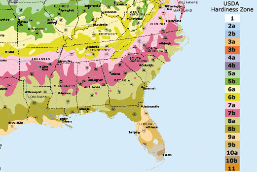
Click on USDA
Hardiness Map (above) for more information and for zipcode linked
gardening advice
What are Zone Maps?
Gardeners need
a way to compare their garden climates with the climate where a
plant is known to grow well. That's why climate zone maps were
created. Zone maps are tools that show where various permanent
landscape plants can adapt. If you want a shrub, perennial, or tree
to survive and grow year after year, the plant must tolerate
year-round conditions in your area, such as the lowest and highest
temperatures and the amount and distribution of rainfall.
The 1990 USDA Hardiness Zone Map
The USDA Hardiness Zone Map is one of several maps developed to
provide this critical climate information. The USDA map is the one
most gardeners in the eastern United States rely on, and the one
that most national garden magazines, catalogs, books, and many
nurseries currently use. This map divides North America into 11
separate zones. Each zone is 10 degrees F warmer (or colder) in an
average winter than the adjacent zone. (In some versions of the map,
each zone is further divided into "a" and "b" regions.)
Great for the East
The USDA map
does a fine job of delineating the garden climates of the eastern
half of North America. That area is comparatively flat, so mapping
is mostly a matter of drawing lines approximately parallel to the
Gulf Coast every 120 miles or so as you move north. The lines tilt
northeast as they approach the Eastern Seaboard. They also demarcate
the special climates formed by the Great Lakes and by the
Appalachian mountain ranges.
Zone Map Drawbacks
But this map has
shortcomings. In the eastern half of the country, the USDA map
doesn't account for the beneficial effect of a snow cover over
perennial plants, the regularity or absence of freeze-thaw cycles,
or soil drainage during cold periods. And in the rest of the country
(west of the 100th meridian, which runs roughly through the middle
of North and South Dakota and down through Texas west of Laredo),
the USDA map fails.
Problems in the West
Many factors
beside winter lows, such as elevation and precipitation, determine
western growing climates in the West. Weather comes in from the
Pacific Ocean and gradually becomes less marine (humid) and more
continental (drier) as it moves over and around mountain range after
mountain range. While cities in similar zones in the East can have
similar climates and grow similar plants, in the West it varies
greatly. For example, the weather and plants in low elevation,
coastal Seattle are much different than in high elevation, inland
Tucson, Arizona, even though they're in the same zone USDA zone 8.

|